
Geotrails & Views
A selection of geotrails, interesting geological views and sites in Cumbria. Go to the Geological Sites Map for Geology Walks (tick the box in top right hand side).
Follow outdoor safety code, keep yourself and others safe.
More new geology walks in the Westmorland Dales, that visit LGS sites.
"Revealing the Foundations" A new publication by Elizabeth Pickett.

Smardale geology walk.
CWT carpark at NY742 083
A beautiful walk through a local nature reserve with interesting geology features and history. Download the guide here.
Orton Scar & Knott.
Start in Orton NY622 082
Lots of limestone features and glacial erratics on this spectacular geology walk, with stunning views. Download the guide here.

Kirkby Stephen & Stenkrith.
Kirkby Stephen NY771 084
Find out about brockram, red sandstone and tufa! See the power of water in the River Eden. Download the guide here.

Blasterfield & Dina Gill.
Roadside parking area at NY632107 A 4.5 mile ice age walk, with intriguing meltwater channels and impressive glacial erratic boulders, which tell us about the area’s icy past. Download the guide here.

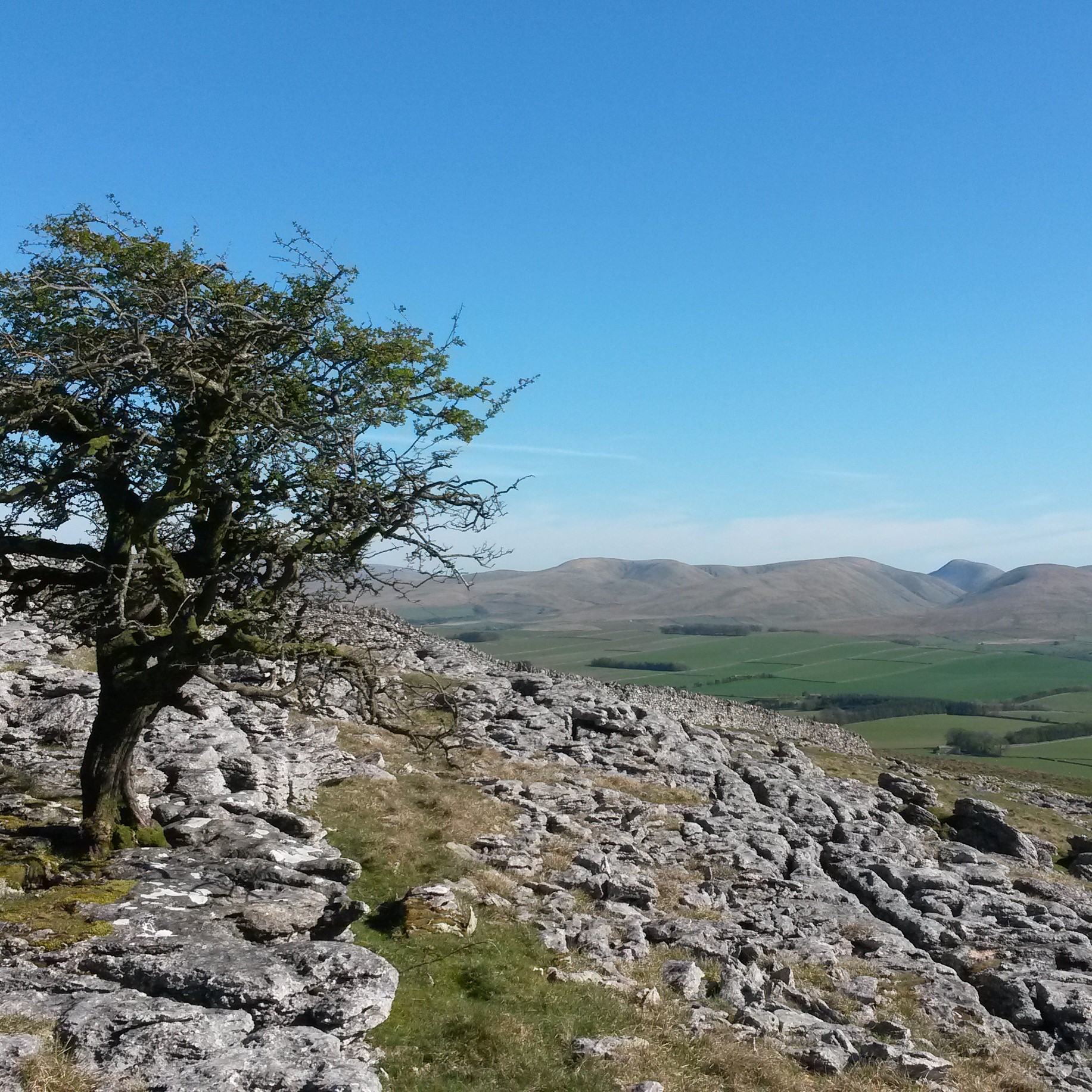
Little Asby Scar.
Park off-road north of Mazon Wath considerately.
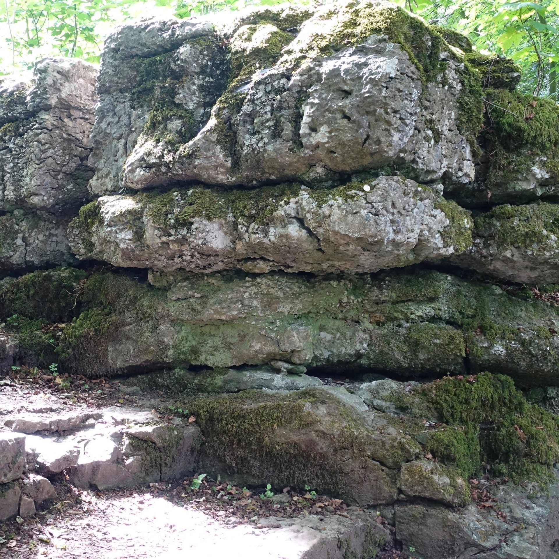
This varied and interesting site in lovely limestone country contains an internationally important Carboniferous reference section and pre- to post-glacial drainage systems. Further information here.

Janny Wood.
Limited parking on the Tommy Road. Access land and bridleway on west bank.
The River Eden flows over an internationally important Carboniferous reference section between the Great Scar Limestone and Yoredale. Further information here.
Some more geotrails and sites of interest across Cumbria:
Honister Geotrail.
Start: Honister Visitor Centre carpark at NY 2238 1357 The spectacular mountain scenery around Honister Pass is the backdrop to this two-hour Geotrail, which explores glacial landforms, slate quarries, and fascinating evidence of volcanic activity from 450 million years ago. See the attached leaflet.

Tebay Lune Bridge walk.
Start: Lune’s Bridge NY 61284 02856 This 2.5 mile walk gives a unique view of the Lune Gorge, the underlying rocks and their influence on the scenery. Look at the all‐round views, and admire the unusual nature of St James Church Tebay. Download a leaflet here.

Newbiggin to Bents walk.
Park neatly on the minor road signed to Asby NY 70317 05315 As you walk north you will walk over progressively younger Carboniferous rocks which are generally covered in glacial deposits. You will need to study the walls to get an idea of the underlying bedrock. Leaflet here.

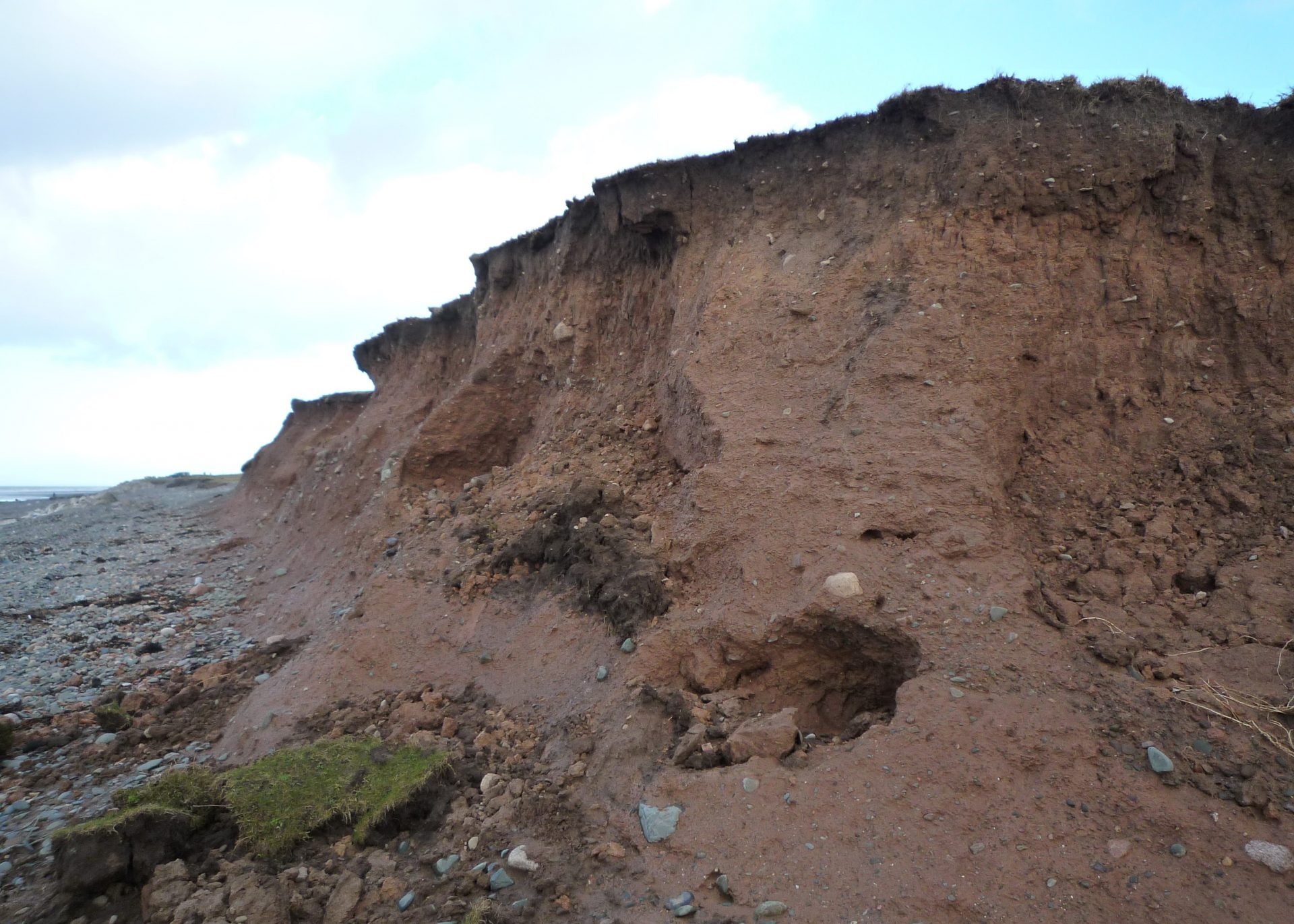
Sandscales Haws.
National Trust car park at SD 200756
The sand dunes here, have national and international conservation importance. Carboniferous limestone bedrock is 60 metres beneath glacial drift, till (unsorted material carried by the glacier and dumped as it melted) and water sorted sands, gravels and clays. Investigate dune features in the attached leaflet.
Rampside Ramble.
Start at The Concle Inn, Rampside.
The salt marsh is an important and complete record of modern sedimentation. It built up after the Causeway to Roa Island was built in 1847; old maps before this time showed a water filled hollow known as Conck Hole.
The attached leaflet also describes some of the glacial deposit features.
Walney West Shore.
Thorney Nook SD 184664 or Hare Hill SD 204628.
Walney is a unique feature of the English coast, a barrier island, with recurved spits at either end, a type of large offshore bar, exceptional in being the result of erosion and reworking of glacial sediments, in an environment with a large tidal range. Find out about the pebbles, the erratics and glacial sediments here.

Eycott Hill Nature Reserve:
NY 394 301 Eycott Hill’s geological story goes back almost 500 million years. Ancient lava flows are sandwiched between older siltstones, mudstones and younger limestones. Leaflet here (Note: White posts pushed over by cattle, walk southwest to follow trail) and educational resources here. Eycott is a SSSI, a National Geological (GCR) site and a Local Geological Site . Managed by Cumbria Wildlife Trust.

Tarn Hows: Easy access mobility trail.
Start: National Trust car park.
This beautiful tarn has an excellent path, from which you can see views of the surrounding fells, but also get close to some of the different rock outcrops. Tarn Hows is at the junction of the Ordovician and Silurian rocks. See the attached leaflet.

Tarn Hows: A geology and landscape trail.
Start: National Trust car park.
A slightly more detailed trail that takes you off the main path in places. It is about 2 miles, so you should allow 2 hours. You will see different rocks within the Borrowdale Volcanics and Windemere Supergroup, plus classic glacial features. See the attached leaflet.

Storth Geotrail:
SD 478 807 This is a lovely 5km route with 18 waypoints (including several LGS sites) exploring landforms and geology around Storth and Sandside in the Arnside and & Silverdale Area of Outstanding Natural Beauty (AONB). Download a 16 page guide by Peter Standing here.
Kendal Limestone Geotrail:
Selected rock exposures with grid references, accessible on walks from Kendal town centre. Download a 21 page full colour guide by Richard Wrigley from Westmorland Geological Society here.

St. Bees Geotrail:
NX 961 118 This coastal route is part of Wainwrights Coast to Coast. There are several LGS sites along the way. Find out more from the geological sites map and search for Fleswick, Birkhams and St Bees Beach. Download a 12 page guide by Mike Dewey here.
Town trails and other interesting sites:

Cockermouth Town Trail.
An interesting walk around Cockermouth, looking at the building stones. Download a leaflet here.

Great Asby Scar SSSI
NY 584574 Orton
Some of the best and most extensive limestone pavement in the UK. Fine out more by looking at the geological sites map and searching for Great Asby. Great Scar Limestone (GSCL)
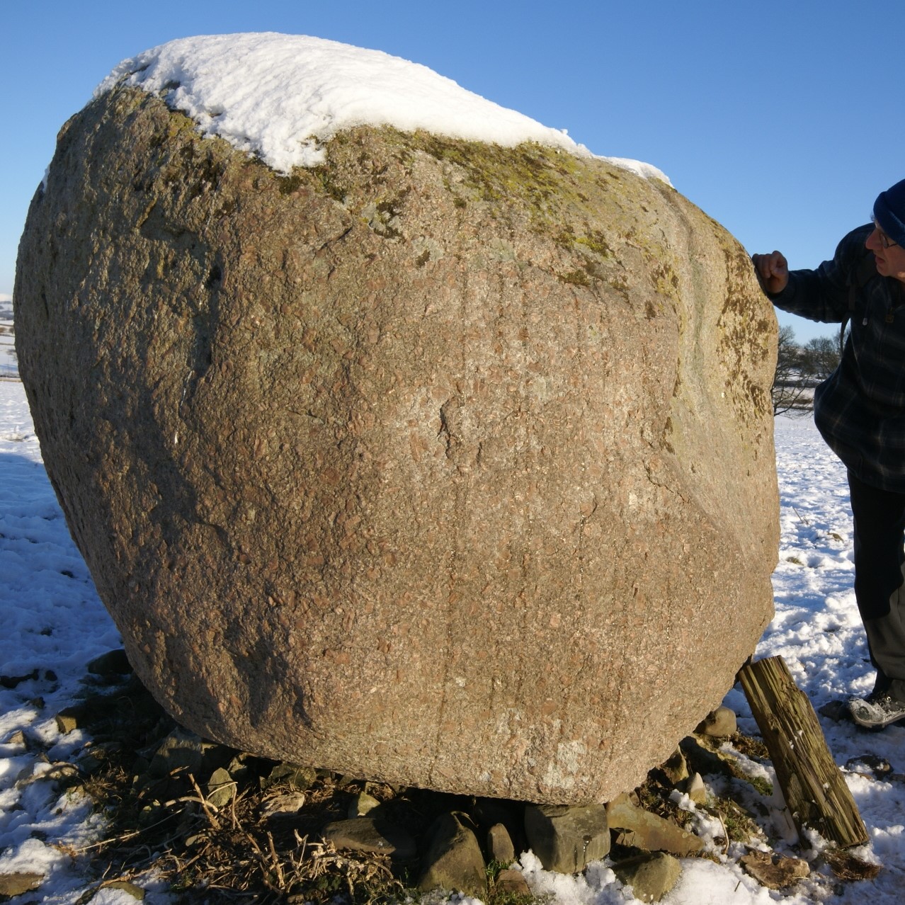
Iconic Rock – Shap Granite.
Shap granite is seen in many erratics across Cumbria and is a useful indicator of ice movement. The Quarry itself is still a working Quarry with no public access. Shap Granite (SHAP).

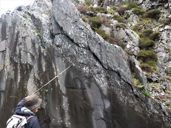
Donkey Rock.
SD 210 868 Broughton
This impressive 10m high quarry face, certainly has a wow factor! It is a little piece of the sea floor as it was some 425 million years ago. These 'bumps' are called flute casts. Windermere Super Group.

The Bowder Stone.
NY 254 164 Borrowdale, Keswick
Its sheer size and how it balances on one corner, has long made this an iconic image of the Lake Ditsrict. A rock fall from Bowder Crag, 150 meters above, is its probable source. Borrowdale Volcanic Group

Kendal Town Geotrail.
Leaflet "Kendal Building Stones" by Geoff Brambles, available by post with other publications here and from Kendal Museum
This is a short mostly level walk around Kendal, pointing out the variety of features in the stones used to build Kendal.


